
Tropical conditions in the Atlantic remain quiet as we enter the third week of the 2025 hurricane season.
The National Hurricane Center is monitoring three tropical waves in the Atlantic basin, including one in the western Caribbean.
The first named storm in the Atlantic basin will be Andrea.
➤ Weather alerts via text: Sign up to get updates about current storms and weather events by location
In the eastern Pacific, former Tropical Storm Dalila has weakened into a post-tropical cyclone as it continues to move away from land but an area of low pressure off Central America is expected to become a tropical depression over the next couple of days.
Meanwhile, some showers and storms are expected in some locations across Florida as temperatures and the heat index continue to climb. Some areas could see a heat index as high as 105.
Here’s the latest advisory from the National Hurricane Center as of 8 a.m., June 16.
What tropical waves, disturbances are in Atlantic basin now? How likely are they to strengthen?

The National Hurricane Center is monitoring three tropical waves in the Atlantic basin.
Tropical wave 1: A tropical wave is in the central Atlantic extending from 02N to 16N with axis near 39W, moving westward at 11 to 17 mph.
Tropical wave 2: A tropical wave is in the central Atlantic extending from 02N to 15N with axis near 50W, moving westward at 11 to 17 mph.
Tropical wave 3: A tropical wave is in the western Caribbean south of 19N with axis near 80W, moving westward at 11 to 17 mph. Numerous moderate to strong convection is ahead of the wave axis over the Nicaragua, Costa Rica and western Panama offshore waters.
“The average first named storm in the Atlantic is June 20, but development over the central and eastern basin looks unfavorable through June at this time,” said AccuWeather lead hurricane forecaster Alex DaSilva.
Eastern Pacific

Conditions in the eastern Pacific 10 p.m. PDT June 15, 2025.
Former Tropical Storm Dalila is now a post-tropical cyclone as it moves west-northwest at 9 mph away from the western coast of Mexico. The National Hurricane Center issued its last advisory on Dalila Sunday night.
An area of low pressure off Central America is expected to become a tropical depression over the next couple of days. Regardless of development, areas of heavy rain are likely across portions of Central America and southeastern Mexico during the next few days.
The next named storm in the eastern Pacific will be Erick.
What do the colored, hatched areas on the NOAA map mean?
The hatched areas on the National Hurricane Center’s tropical outlook map indicate “areas where a tropical cyclone — which could be a tropical depression, tropical storm or hurricane — could develop,” said National Hurricane Center Deputy Director Jamie Rhome.
The colors make it visibly clear how likely a system could develop, with yellow being low, orange medium, and red high.
The National Hurricane Center generally doesn’t issue tropical advisories until there is a named storm, but there is an exception.
“If a system is near land and there is potential for development, the National Hurricane Center won’t wait before it issues advisories, even if the system hasn’t become an actual storm. This gives residents time to prepare,” Rhome said.
Florida weather radar for June 16, 2025
Florida weather forecast for June 16, 2025
Pensacola, western Panhandle: Showers and thunderstorms likely, mainly before 4 p.m. Expect seasonably warm temperatures through the week, with highs in the upper 80s to lower 90s each afternoon. By the weekend, temps will approach the mid to upper 90s in some spots, with heat indices exceeding 100 degrees. There’s a potential for heat advisories in some locations.
Tallahassee, central Panhandle: There’s a good chance for showers and storms over the next several days, bringing dangerous lightning, heavy rain and strong winds. High near 89, with heat index values as high as 100.
Weather watches and warnings issued in Florida
When is the Atlantic hurricane season?
The Atlantic hurricane season runs from June 1 through Nov. 30.
Ninety-seven percent of tropical cyclone activity occurs during this time period, NOAA said.
The Atlantic basin includes the northern Atlantic Ocean, Caribbean Sea and Gulf of America, as the Gulf of Mexico is now known in the U.S. per an order from President Trump. NOAA and the National Hurricane Center are now using Gulf of America on its maps and in its advisories.
When does hurricane season start? When is the peak?
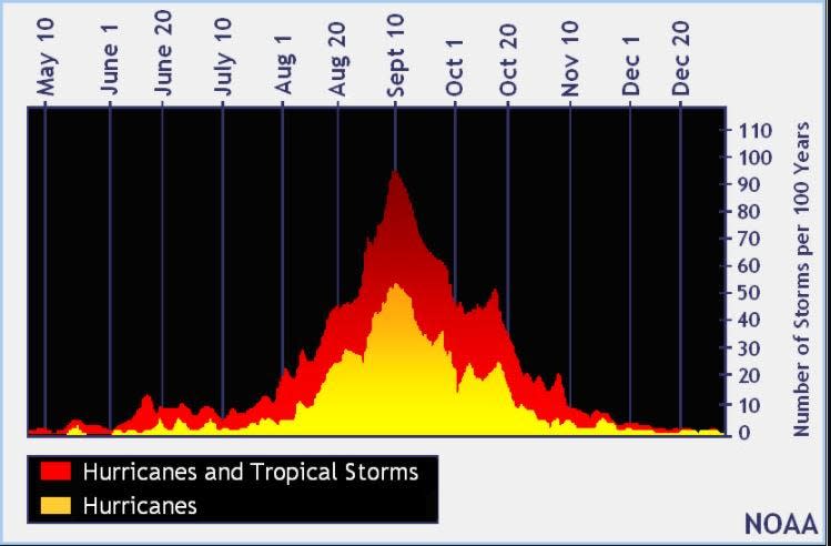
Hurricane season’s ultimate peak is Sept. 10 but the season goes through Nov. 30. Credit: NOAA
The peak of the season is Sept. 10, with the most activity happening between mid-August and mid-October, according to the Hurricane Center. Hurricane season starts June 1 in the Atlantic basin.
National Hurricane Center map: See what forecasters watching now
Systems currently being monitored by the National Hurricane Center include:
Why does NHC say ‘tropical cyclone’ on its maps instead of hurricane or tropical storm?
Tropical cyclone is the generic term used by the National Weather Service, NOAA and the National Hurricane Center for any tropical system, even if it’s in the tropical Atlantic basin.
To be more precise, a tropical cyclone is a “rotating, organized system of clouds and thunderstorms that originates over tropical or subtropical waters and has closed, low-level circulation,” NOAA sadi.
Once maximum sustained winds reach 74 mph, what it is called is determined by where it originated:
Hurricane: for storms in the North Atlantic, central North Pacific, and eastern North Pacific.
Typhoon: for storms in the Northwest Pacific.
Cyclone: for storms in the South Pacific and Indian Ocean.
Interactive map: Hurricanes, tropical storms that have passed near your city
Stay informed. Get weather alerts via text
What’s next?
We will update our tropical weather coverage daily.
Download your local site’s app to ensure you’re always connected to the news. And look for our special subscription offers here.
This article originally appeared on The Daytona Beach News-Journal: Hurricane season has NOAA tracking 3 tropical waves