
Rain will continue to pour across Central Indiana before mixing with sleet and then tapering off on Sunday night, according to the National Weather Service.
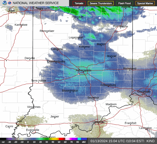
Indianapolis remained under a flood warning through 1 p.m. Saturday as Friday night’s rainfall recedes from roadways. A flood watch will stay in place until 8 a.m. Sunday.
The NWS predicts that by the time the showers end, parts of Central Indiana will have received up to 7 inches of precipitation.
More: Indianapolis remains at high flood risk Saturday. Here’s how to check road conditions
Storm systems are traveling with a cold front moving through the area “like cars on a highway,” NWS meteorologist Matthew Eckhoff said.
The NWS forecasts that the temperature will fall to near 49 degrees Saturday evening, dropping further to 39 degrees overnight. Sunday will be slightly cooler with a high of 46 during the day and 34 overnight.
Monday will begin as a temperate, sunny day with a high of 54 degrees before the cold front brings a chance of a rain-snow mix in the afternoon and evening. Temperatures will dip as low as 27 degrees on Monday night, with wind gusting up to 23 mph.
Indianapolis weather radar
Indiana travel advisories
Weather info you need
🚨 Indiana Weather Alerts: Warnings, Watches and Advisories.
⚡ Indiana power outage map: How to check your status.
💻 Internet outages: How to track them.
🚫 What you should and shouldn’t do when the power is out.
🐶 Your neighbor left their pet outside. Who you should call.
Where to report power outages and downed lines
AES Indiana customers: 317-261-8111
Duke Energy customers: 1-800-343-3525
How to report downed traffic signals or tree limbs blocking a road
If you encounter a downed traffic signal or a limb blocking a roadway, contact the Mayor’s Action Center at 317-327-4622 or online at RequestIndy.gov. When calling after hours, press “2” to be connected.
Indiana road conditions
Check road conditions, including road closures, crashes and live webcams using Indiana’s online Trafficwise map at 511in.org, or visit our gridlock guide page for live traffic cams and more.
INDOT’s CARS Program provides information about road conditions, closures and width and weight restrictions. The website has a color-coded map of Indiana’s highways and highlights hazardous road conditions and travel delays.
The interactive map also shows road work warnings, closures, roadway restrictions and other information helpful to drivers.
Ryan Murphy is the communities reporter at IndyStar. She can be reached at rhmurphy@indystar.com.
This article originally appeared on Indianapolis Star: More rain, potential flooding for Indianapolis before cold snap