
Severe storms raked across Nashville and Middle Tennessee on Saturday, bringing multiple tornado warnings, at least one possible tornado, plus torrential rains and high winds all around the region.
Heavy rain and flooding are the main areas of concern through the weekend, according to the National Weather Service Nashville. Areas west of Nashville, like Clarksville and Waverly, could see between 6-8 inches of additional rainfall through Sunday on already soggy ground.
“Due to this amount of rain, major life-threatening flooding is expected to start late this afternoon and continue through Sunday morning,” the forecast said.
More information on flood preparation and safety can be found at weather.gov/safety/flood.
Keep up with weather updates and alerts: Download our app for the latest and get alerts delivered to your phone.
Tornado confirmed near Cross Plains
The National Weather Service said at least one tornado touched down in Cross Plains as sirens sounded across the region Saturday evening. The tornado was seen 14 miles northwest of Gallatin, moving east at 55 mph.
The National Weather Service issued a tornado watch for much of middle Tennessee through 9 p.m. Saturday evening, including Cheatham, Davidson, Dickson, Maury, Robertson, Rutherford, Sumner, Williamson and Wilson counties.
See a complete list of active watches and warnings here.
Power outages sweep Middle Tennessee
More than 62,000 customers were without power across Nashville and Middle Tennessee, according to outage maps from Nashville Electric Service, Middle Tennessee Electric, Cumberland Electric Membership Corporation and Dickson Electric. Most of the outages were concentrated in Nashville, where nearly 49,000 were without power as of 6 p.m.
Tornado and storm damage reports in Nashville, Middle Tennessee
Videos, photos show Nashville storm damage, likely tornado
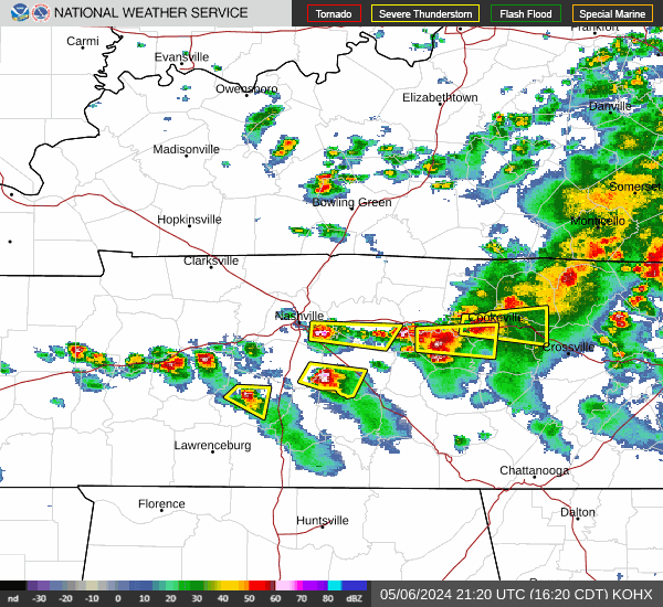
Nashville, Middle Tennessee weather radar
Tornado, flood warnings in Tennessee: Map the latest
Week of stormy weather turns deadly
The latest round of severe weather comes after deadly storms swept through Tennessee on Wednesday night and Thursday. Officials said the storms have killed 10 people. Five were reported in McNairy County, two were in Fayette, and Carrol, Obion and Tipton counties each had one death.
What is flash flooding?
Flash flooding usually begins within six hours, but often within three hours, of heavy rain or mass amounts of water accumulating in an area, according to the National Weather Service.
This type of flooding usually happens very quickly and catches people off guard. It can be caused by a number of things, but is often due to extremely heavy rainfall from thunderstorms.
“The intensity of the rainfall, the location and distribution of the rainfall, the land use and topography, vegetation types and growth/density, soil type, and soil water-content all determine just how quickly the flash flooding may occur, and influence where it may occur,” writes the National Weather Service.
Flood watch vs. flood warning: What is the difference?
A flood watch and a flood warning are two different things. Here’s the difference.
A flood watch indicates that the conditions are favorable to flooding in an area that is under a watch. These flood watches are usually issued hours and even days ahead of the weather event that could cause the flooding.
A flood warning means that the flooding that could be harmful and poses a serious threat to property and people is expected. This too can be issued hours and days ahead of time based on forecast predictions.
Anytime flooding is a risk people should use caution. Water levels can change rapidly during periods of heavy rainfall.
What the difference between a tornado watch and tornado warning?
When a tornado watch is in place tornadoes are possible in and near the watch area, according to the National Weather Service.
The National Weather Service suggests people who are in the warning area review and discuss their emergency plans, check supplies and have a safe room incase the weather takes a turn for the worse.
When a tornado warning is issued it means a tornado has been sighted or indicated by weather radar. There is imminent danger to life and property.
Here are some suggestions from the National Weather Service if a tornado warning is issued for your area:
Move to an interior room on the lowest floor of a sturdy building
If in a mobile home, a vehicle, or outdoors, move to the closest substantial shelter and protect yourself from flying debris
Warnings typically are for a much smaller area that may be impacted by a tornado identified by a forecaster on radar, a trained spotter or law enforcement who is watching the storm, according to National Weather Service.
Tornado warnings are issued by your local forecast office.
This article originally appeared on Nashville Tennessean: Track Nashville tornado, storm damage reports, Middle TN power outages